


Parks, public lands, and creative journeys: An interview with Natalie Teboul, WNP-award recipient

Natalie Teboul, educator and creator of Traveling Miss T.’s Math Maps©, is Western National Parks’ (WNP) 2025 Stewart L. Udall Award winner. She was recognized for her work creating interactive STEAM materials for students that allow them to “travel” to public land sites throughout the country without ever leaving the classroom. WNP interviewed Natalie about her career, how she became fascinated by the parks, and what it takes to create her Math Maps. Learn more about WNP’s awards and how to nominate a national park hero on our awards page.
Traveling to the national parks by Coordinate Plane
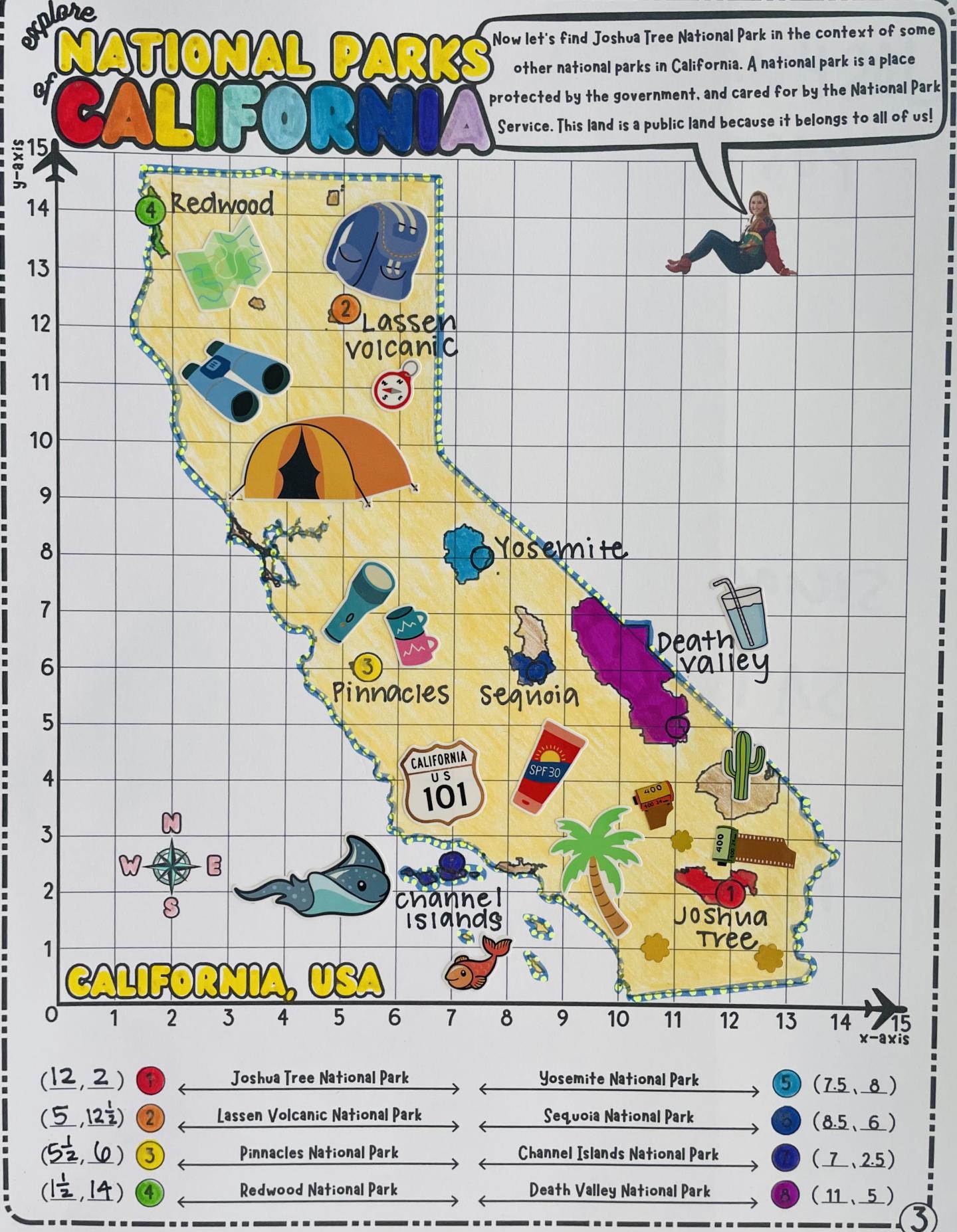
If a learner wants to take a trip with one of Traveling Miss T.’s Math Maps, they have plenty of destinations to choose from. Cabrillo National Monument, Joshua Tree National Park, Denali National Park and Preserve, and various San Diego County Parks are among the more than 50 public land sites that they can visit.
It begins with a physical worksheet. Learners first find and plot points on their Math Maps before labeling locations and coloring their final maps. Then, if they want to learn more about the places they marked, they can visit Miss T.’s website, where they click on the locations associated with their map and watch videos set in that exact place. For national park and public lands maps, these videos often include short educational clips by experts who work at the park. “I want the voices of the people who are there [at the park] every single day who really, really know the place that we’re exploring,” she said.
How the maps are made
Creating these educational materials can take significant time—often several months and sometimes a year or more. It begins when Natalie reaches out to a “friends group” or nonprofit that supports the public land site. Each map goes through an approval process with the managing agency. Part of the process is securing permits for any type of filming at the site. Natalie then creates the educational materials, which include writing the original curriculum and adapting it to different grade levels. She may take a trip to the public land site to film. She also makes use of ArcGIS Story Mapping, a technology that she began using in July 2025. This Esri technology provides an early introduction to Geographic Information Systems (GIS).
Learners from across the world are learning about national parks without ever leaving the classroom thanks to these educational materials. As many of her materials are for elementary school students, she emphasizes the importance of visiting parks respectfully.
If you can bring the park to a kid...even if it’s an imaginary adventure, it’s giving them that initial exposure that they need to eventually go later and protect it as an adult.
—Natalie Teboul, educator and creator of Traveling Miss T.’s Math Maps©


1 of

A love of teaching and the parks
Making maps for kids wasn’t something Natalie originally envisioned—especially since she hadn’t anticipated being an educator in the first place. Natalie’s career as an educator began unexpectedly after graduating with a bachelor’s degree in human development from Binghamton University. She applied for a position with the New York City Teaching Fellows, where, after scoring high on a math test, she was assigned to Urban Assembly School for Applied Math and Science in the Bronx.
“I completely fell into it,” she said, “...but then later really realized how much I loved teaching and how much I loved math.”
She completed her Master of Science in Education, where she specialized in seventh-through-twelfth grade mathematics, at St. John’s University, and would later earn a Master of Fine Arts in Creative Writing at San Diego State University, where she would write about her experiences as a teacher.
She moved to San Diego for her second master’s degree in 2016, which she describes as a “huge lifestyle change and the best decision I have ever made.” Natalie was born, raised, completed her bachelor’s and first master’s, and began her career in New York City, so moving to the West Coast opened an entirely new world.
She was working as a fifth-grade teacher when the COVID-19 pandemic began. This transformative event not only changed the way she taught but also introduced her to the national parks. Being from New York City, Natalie had never set foot in a national park before. Her boyfriend at the time—now husband—is from the Lake Tahoe area and grew up camping and exploring the outdoors. In 2020, the two of them took a road trip to several national parks. Natalie fell in love with them.

“I saw the Grand Canyon. We went to Zion. We did Black Canyon of the Gunnison. It was just like this incredible...glimpse into something that I had never experienced as someone from New York City.”
Due to the COVID-19 pandemic, Natalie could not return to in-classroom teaching. To get her students excited about learning during virtual school sessions, she started to get creative.

Natalie’s first foray into geography began years earlier, when she taught the 50 states and their capitals to her students, as part of the fifth-grade curriculum. She created a state fair project for her students where they created maps of their assigned states and wrote persuasive essays to encourage people to visit. The states would serve as jumping off points when she began designing her Math Maps for students.
While teaching in the classroom, Natalie created highly immersive experiences with her students, complete with themed decorations. Recreating that same atmosphere and energy on Zoom was a challenge. She regularly asked herself: “How do I bring the magic?”

Stewart L. Udall Award
Saluting those who work to boost park interpretation programs, carry the park message to popular audiences, or rally broad public support for parks.

Often, the answer was in a themed curriculum. “I was trying to make all of my Zoom calls have a theme. So, it was like, this week we’re doing a Marvel activity...this week we are doing Hogwarts. I was creating adventures or field trips to different imaginary places.”
At the time, Natalie was trying to determine how she could create learning materials that could incorporate her field trip ideas. She began with the 50 states and then got the idea to start creating maps of the national parks and other public land sites.
“I realized that at every single national park, the first thing you're given when you enter is a map,” she said. And she wondered at the time, “Why don't they have maps for kids?”

Bringing even more of the world to learners
Today, Natalie has partnered with organizations including Joshua Tree National Park Association, San Diego Parks Society, The EcoLogik Institute, and Huron-Clinton Metroparks. Denali Education Center even hosted her at the Alaska park for eight days as she worked to develop the maps of Denali. She would eventually like to make maps of Redwoods National and State Parks, Hawai’i Volcanoes National Park, as well as a larger more immersive project highlighting the many sites along historic Route 66. For future materials, she wants to emphasize how public land sites are often connected to one another, as they share history, heritage, and stories.
While Natalie is returning to in-person teaching in August of 2026—she'll be teaching fourth grade—she remains committed to completing Traveling Miss T. projects over her breaks, and continuing to release a Map of the Month. She views her work as part of an effort to create future environmental and park stewards through accessible materials.
“We have this huge issue with equity and access when it comes to our parks, right? So getting kids physically to the park, it takes time, it takes grants, it takes money, it takes busing,” she said. “But if you can bring the park to a kid, even if it's only by coordinate plane, even if it's an imaginary adventure, it's giving them that initial exposure that they need to eventually go later and eventually protect it as an adult.”
Visit our awards page to learn more about the Stewart L. Udall Award.
“[Winning this award] meant everything...At the end of the day, I really believe in what I’m doing, and when someone else takes notice of that...that recognition means so much.”
By Nikki Stavile
Continue reading


1 of
